October 29, 2005
Through the Glass Frighteningly
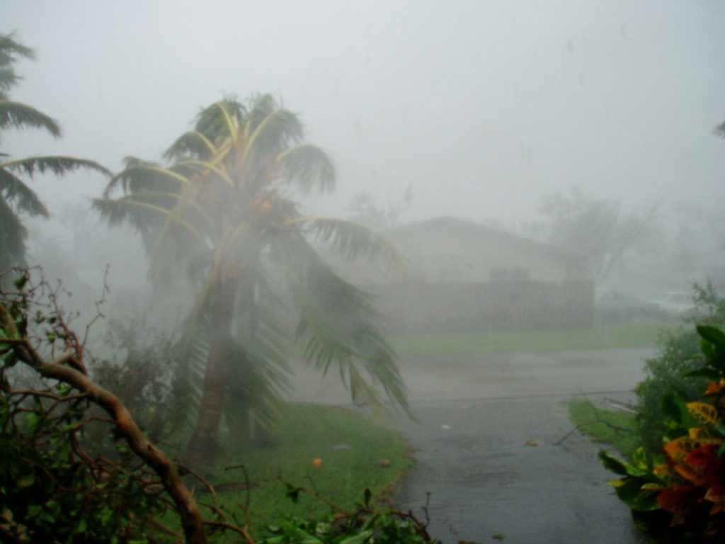
I took a number of photographs during the storm but single images have a difficult time conveying the magnitude of the incredible winds that Wilma cast against us.
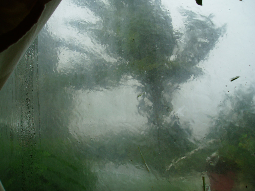
The previous entry showed the hurricane from the front, or eastern view of our house, where I was protected by the house itself from the westerly winds. This photograph was taken through one of our rear full height windows, on the west side of the house.
I would like to point out one thing: We did have plywood against these windows. The one covering this particular window had blown off. It was rather frightening knowing the power of the winds buffeting toward that side of the house, only inches away from me.
I got away from there quickly.
Posted by Bastique at 7:35 PM | Comments (1)
120 Mile per Hour Winds
The power just came on this morning.
Have I mentioned that I've had enough of hurricanes? Now there's Wilma. I have a great deal to discuss about this particular hurricane and aftermath. But I wanted to start off with a few photographs. There will be time to talk.
Posted by Bastique at 4:57 PM | Comments (0)
October 18, 2005
White Ibises
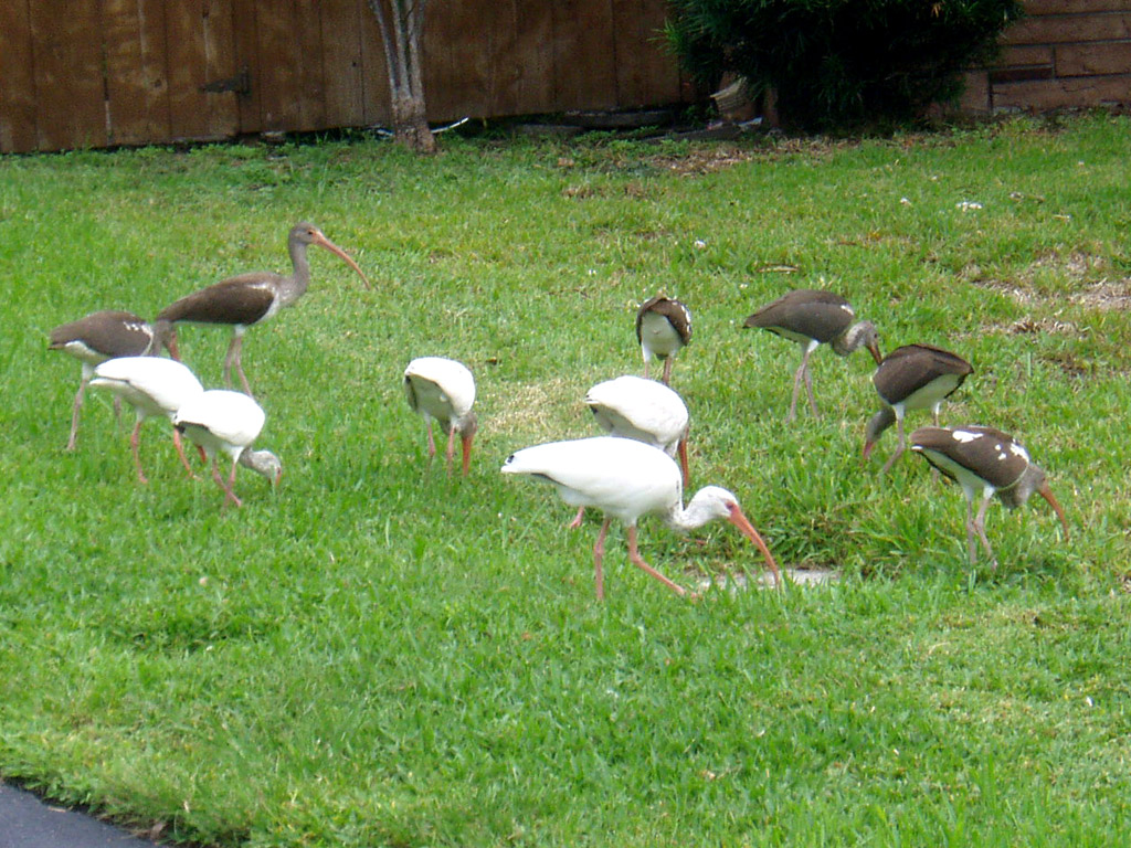
 A co-worker and I were recently talking about local wildlife and I mentioned how fascinated I was by watching white ibises, and how lately I've seen local flocks that included numerous juveniles, birds that have not yet achieved a full white state; and how entire flocks seem less afraid to be around humans. To my surprise, she had no idea what an ibis was.
I did a search on the internet and wanted to show her a picture, but along the way, I discovered that ibises do not reach adulthood until they are five years of age. Furthermore, a Eudocimus albus, as they are known to the scientific community, can live up to 20 years old in the wild. At that age, perhaps these birds are becoming use to being around humans in neighborhoods like mine that take care of our ducks, grebes and other waterfowl.
Yesterday I was driving down the street and caught a foraging flock:
Posted by Bastique at 9:29 PM | Comments (2)
October 17, 2005
So much to say, so little to gather
I have plenty of things to talk about. As I make my way through each day, I come up with things to provide to my blog, little vignettes and amazing streams of consciousness that provide great new insights into the mystery of humankind and the answers to the universe in general.
What I don't have is a great amount of time and determination to sit down and relate these things here. Since I left to pick up Michael on Tuesday morning, it has been a non-stop flurry of activity, from housecleaning to meetings to shopping to softball to work, and by the time I sit down here in front of the computer, I don't have enough enthusiasm or brain activity to do more than surf throughout the web.
So many things I've planned to say.
Like telling you about my friend Vinny, who is now country western DJing at the new bar, Steel (formerly the Eagle) on Thursday nights.
Or talking about the letter W's first storm, Wilma.
Or rant on about the increasingly pitiful excuses conservatives are making for this criminal of a president.

Paul Rodgers and QueenI don't even have time to talk about how much I love Paul Rodger's vocals on Queen's new release of Bohemian Rhapsody.
But I can't seem to draw one thought together long enough to make any of these worth my blog's time. Maybe it's the full moon.
I'd like to get a good night's sleep one evening soon. Then maybe I'll be able to put a few interesting words together.
Posted by Bastique at 11:36 PM | Comments (0)
October 12, 2005
A drive from Eglin
Well, you all will be glad to know that Michael is safe and sound at an undisclosed location in Dania Beach. The drive and the opportunity to spend nearly 12 hours straight with him was a huge delight. And although I've spent quite a bit of time the last few years in numbness about the relationship, I'm finally glad I waited.
No, there'll be no declarations about absolute devotion anytime soon. But I will say that I'm confident that we've got something to work on.
Peace.
Posted by Bastique at 11:08 PM | Comments (1)
October 11, 2005
The Short Happy Life of Vince
I was checking out the National Hurricane Center's Website to see how far Global Warming would take us this year as far as Tropical Storms. Hurricane Stan had just blown himself off of Mexico and Tammy--while not the strongest of storms was certainly making her presense known off the southeast coast by deluging us with rain for several days going. What happened to the good old days of the 1990s when you could go three, maybe four years without any major tropical weather effect?
A storm was brewing in the middle of the Atlantic...and had it materialized, it would have enjoyed the rather unlikely name of "VINCE" (The first named storm with a "V" name). I immediately messaged my friend Vinny, who, having a name that starts with "V", really never expected to be remotely connected with a tropical storm. Alas, it didn't appear that the center-Atlantic system would do anything. However, another storm would soon form in the Eastern Atlantic, of all places:
ZCZC MIATCDAT3 ALL
TTAA00 KNHC DDHHMM
TROPICAL STORM VINCE DISCUSSION NUMBER 1
NWS TPC/NATIONAL HURRICANE CENTER MIAMI FL
11 AM EDT SUN OCT 09 2005
THE LOW PRESSURE SYSTEM OF NON-TROPICAL ORIGIN THAT HAS BEEN NEARLY STATIONARY IN THE FAR EASTERN ATLANTIC... IN BETWEEN THE AZORES AND THE CANARY ISLANDS... HAS BEEN ACQUIRING TROPICAL CHARACTERISTICS DURING THE PAST 24 HOURS OR SO. WHETHER OR NOT THIS SYSTEM IS NOW A TROPICAL OR A SUBTROPICAL STORM IS SOMEWHAT OF A SUBJECTIVE DETERMINATION. EVEN THOUGH THIS SYSTEM IS SITUATED OVER SEA SURFACE TEMPERATURES OF 23-24 CELSIUS AND IS BENEATH A LARGE MID/UPPER LEVEL TROUGH... IT NOW HAS SEVERAL CHARACTERISTICS THAT WARRANT CLASSIFICATION AS TROPICAL STORM VINCE.
Within hours, it would strengthen into something a bit more impressive.
5 PM EDT SUN OCT 09 2005
IF IT LOOKS LIKE A HURRICANE... IT PROBABLY IS... DESPITE ITS ENVIRONMENT AND UNUSUAL LOCATION. MOST AVAILABLE DATA SUGGESTS VINCE HAS BEEN STRENGTHENING TODAY. IN FACT... THE CIRA INTENSITY ESTIMATE BASED ON THE EARLIER AMSU OVERPASS NEAR 07Z WAS 50 KT AND 995 MB... SO VINCE WAS PROBABLY EVEN A LITTLE STRONGER THIS MORNING THAN INDICATED IN THE PREVIOUS ADVISORY. MORE RECENTLY... METSAT-8 IMAGERY REVEALS THAT THE EARLIER RAGGED EYE FEATURE WITH ABOUT 20 N MI DIAMETER HAS CONTRACTED TO 15 N MI AS A BONA FIDE EYE. SOME ANTICYCLONIC OUTFLOW ALOFT IS NOW DISCERNIBLE AROUND THE DEEP CONVECTION... ALTHOUGH THE CONVECTIVE TOPS REMAIN A BIT WARMER THAN IN MOST HURRICANES.
Indeed the hurricane was unusual, the forecest map had the hurricane center coming out of the map scale and right into northern Portugal.
But later on...
11 PM EDT SUN OCT 09 2005
THE EYE OF VINCE IS BECOMING LESS WELL-DEFINED...AND THE AMOUNT OF COLD-TOPPED CONVECTION SURROUNDING THE EYE HAS DECREASED. MOREOVER...THE CLOUD PATTERN IS BECOMING INDICATIVE OF INCREASING WESTERLY SHEAR AS THE DENSE OVERCAST HAS BECOME SOMEWHAT ERODED OVER THE WESTERN SEMICIRCLE. ALL OF THIS IS SUGGESTING THAT A WEAKENING TREND IS IMMINENT...IF IT IS NOT ALREADY UNDERWAY. SUBJECTIVE DVORAK CLASSIFICATIONS AND OBJECTIVE T-NUMBERS STILL SUPPORT AN INTENSITY OF 65 KT...ALTHOUGH AMSU INTENSITY ESTIMATES HAVE NEVER QUITE SUPPORTED HURRICANE STRENGTH.
So was Vince truly a hurricane, or just an atmospheric anomoly? As of this morning, weather personnel didn't even seem secure on its location:
5 AM EDT TUE OCT 11 2005
VINCE'S DATA T NUMBERS FROM TAFB AND SAB AT 06Z WERE NON-EXISTENT...WITH JUST A VERY SMALL AREA OF COLD CONVECTION REMAINING TO THE EAST OF THE CENTER. NEITHER OF TWO SCATTEROMETER PASSES...ONE OVER THE EASTERN SEMICIRCLE AT 18Z AND ONE IN THE SOUTHWEST QUADRANT AT 00Z...SHOWED ANY WINDS OF TROPICAL STORM FORCE...AND INDEED THE SECOND PASS CALLS INTO QUESTION THE EARLIER 40 KT SHIP REPORT. A QUIKSCAT PASS AT 06Z SHOWED SOME RAIN-FLAGGED 35-40 KT VECTORS...BUT CLOUD MOTIONS AND COASTAL SURFACE OBSERVATIONS SUGGEST THAT THE QUIKSCAT VECTORS ARE CONTAMINATED. VINCE IS THEREFORE DOWNGRADED TO A TROPICAL DEPRESSION WITH THIS ADVISORY. WITH NO DATA T NUMBERS...CONTINUING VINCE'S STATUS AS A TROPICAL CYCLONE ANY LONGER IS UNWARRANTED.
The weather people were having a bit of fun with this one:
AS THE SHORT HAPPY LIFE OF VINCE IS NOW OVER...THIS WILL BE THE LAST ADVISORY.
THE HISTORICAL RECORD SHOWS NO TROPICAL CYCLONE EVER MAKING LANDFALL ON THE IBERIAN PENINSULA. BASED ON SURFACE REPORTS FROM FARO PORTUGAL...THE CENTER PASSED JUST TO THE SOUTH OF THE COAST OF PORTUGAL...BEFORE BECOMING THE FIRST TROPICAL CYCLONE TO MAKE LANDFALL IN SPAIN.
Another Tropical first for the 2000s? How many "firsts" are going to occur before someone realizes that hey, this is more than just a series of unusual weather patterns. I discussed this before, when talking about last year's "first" a South Atlantic hurricane in March (See Weather Observations).
Anyone who says that there is no global warming either has their head in the sand or is lying for corporate interests. The evidence is getting stronger and more powerful on a weekly basis.
As far as Vinny, he's got his storm. And it's an historical first. Congratulations, Vince.
Posted by Bastique at 11:54 AM | Comments (1)